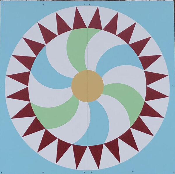
Block Name: “Rising Sun”
Host Name: Cavan Monaghan Municipal Office
Address: 988 County Road #10, Millbrook ON

The Rising Sun quilt block is a traditional block; the earliest date for this historically though is uncertain. It definitely dates back to at least the 1850s. Nancy Cabot, a columnist for the Chicago Tribune in the 1930s, wrote that this block originated in 1778. Her historical accuracy, however, has been called into question by many people. Whatever the date in history, we do know it is an old design. Nancy Cabot also noted that this block has borne different names other than Rising Sun: Wheel of Fortune, Cogwheel and Rolling Wheel. This design was chosen for our Trail because the subject matter and colours emphasize how important agriculture is to Cavan Monaghan. The sun and weather are crucial to growing food. Blue has been chosen for the colour of the sky; green captures the crops, fallow fields and forests. The curving rays emanating from the centre beautifully represent the rolling hills of Cavan Monaghan. The red triangles in the outer circle remind us of the beauty of sunrises and sunsets over our fields and hills.
The Township of Cavan Monaghan is located in the Southern Kawarthas and is a landscape of rolling hills, forest, streams, swamp and arable land -- all shaped by glaciers eons ago. What we now call Cavan Monaghan is located on the Treaty 20 Michi Saagiig territory and in the traditional territory of the Michi Saagiig and Chippewa Nations, collectively known as the Williams Treaties First Nations, which include Curve Lake, Hiawatha, Alderville, Scugog Island, Rama, Beausoleil, and Georgina Island First Nations. These First Nations have lived on this land from time immemorial, hunting, trapping, fishing, farming and gathering the fruits and nuts of the land.
The Township was surveyed beginning in 1817 and European settlement began shortly afterwards. One of the surveyors, John Deyell, became one of our earliest European settlers.
The barn quilt is displayed on the south-facing wall of the Township Offices. The land where this building is located has passed through many hands: the 1861 map, published by George Tremaine, lists William McNish as the owner, while the 1878 Belden atlas shows it belonging to James Stanton. The building, opened in 1965, was erected as South Cavan Public School, in order to bring together students from eight small schools (often only one room).
The rising sun is a universal symbol of hope: a daily reminder that each day brings fresh opportunities.
Block designed by: Kate DeKlerck
Block painted by: Maya deMaria
Barn Quilt Trail Etiquette:
Please Respect Private Property. Most quilt blocks are installed on private property and should be viewed from the road.
Please do not trespass. In some cases - only where clearly indicated - the barn quilt may be located on a business and the property may be open to the public.
Please drive carefully. Stopping along busy roads can be dangerous and illegal. Use caution when slowing or stopping near a site
